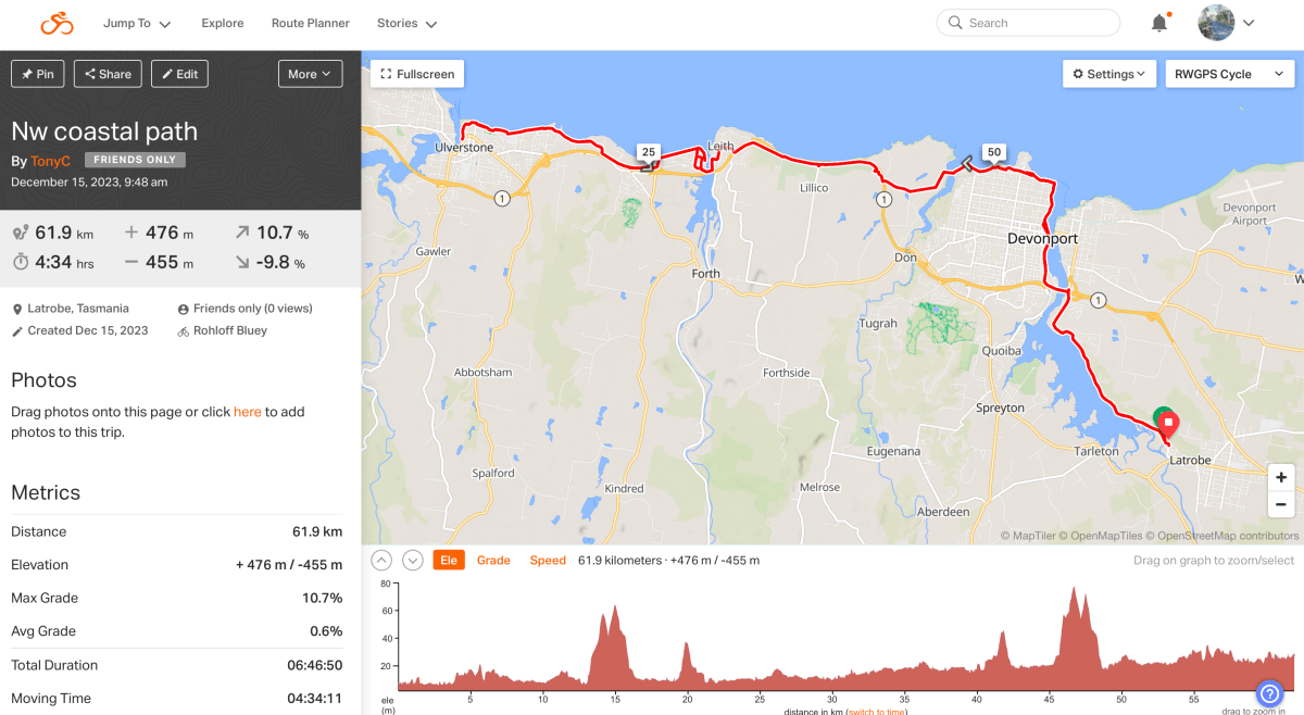
Not “The” missing link but one more link in the proposed Tasmanian NW Coastal Pathway from Latrobe to Wynyard.
The new link is a sizeable piece of shared pathway linking Don to Leith. From Leith, use of quiet roads gets you to the existing pathway into Ulverstone making it possible to cycle from Latrobe to Ulverstone on shared pathways and a stretch or two of quiet roads. 30 kilometres altogether. There’s quite a bit more of it finished or being developed but most is not linked up for any distance as yet. It will be a while before the entire 110 kilometres can be ridden.
Anyway, today I will be riding Latrobe to Ulverstone, meeting Colin in Ulverstone to ride back to Latrobe together. 60k in all.
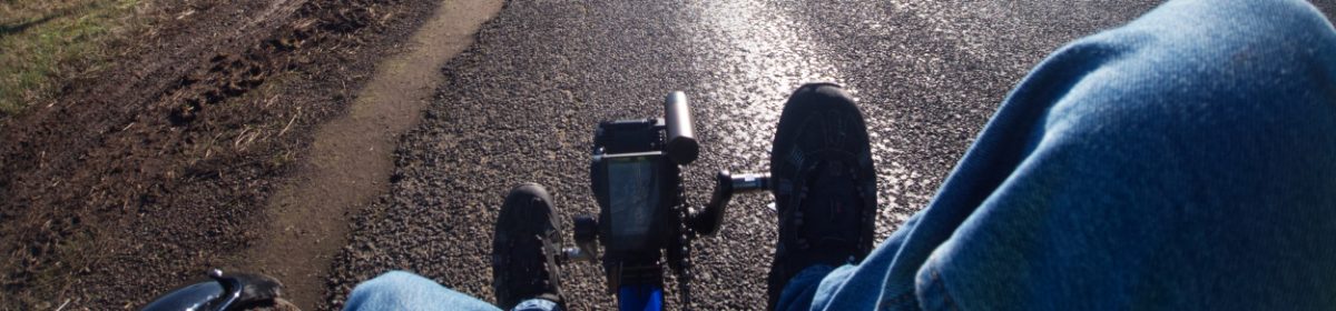
I parked behind the Axeman’s Hall of Fame, Latrobe and got ready to go. It is extreme UV at the moment and I can get burnt even on a cloudy day. Today it should be sunny so I brought along the sun canopy. It makes the trike too tall to fit in the trailer so I had to detach it and then re-attach it as part of the readying process. Glad I bothered as the sun was feeling powerful already.

Once prepared I set off along the shared path into the park.

Here the tracks are compressed gravel and quite narrow. It’s OK when there’s not too many people around – as today.
The ride takes us through the park following the river to get to the start of the NW Coastal Path.
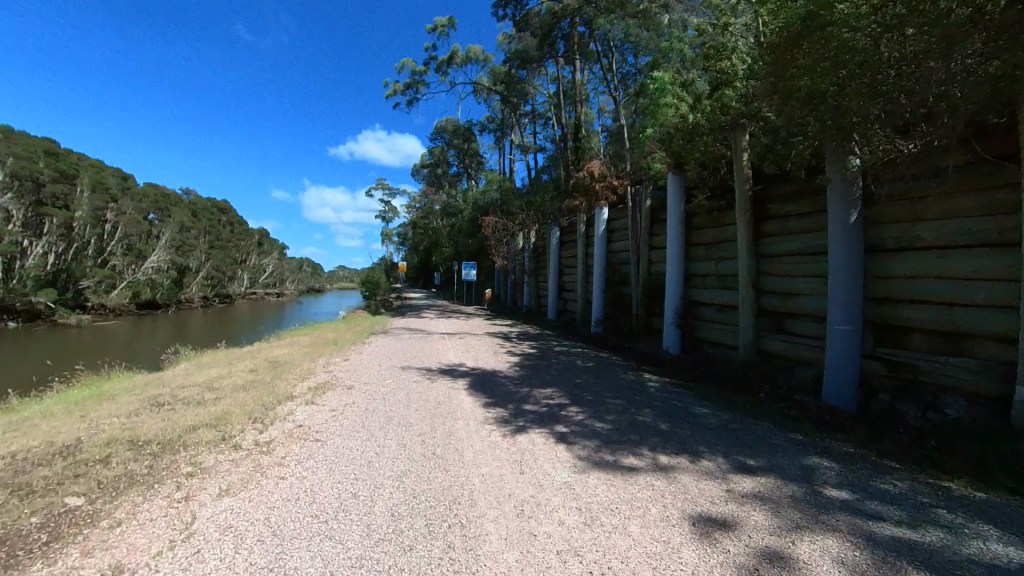
After a while the surface changes to the concrete trail laid specifically for the pathway a couple of years ago. Initially it’s a bit undulating with short steep descents / ascents going through a bushy area and then it flattens out to a more open aspect with good views of the river. There are other trail users on bikes and walking as this section is usually quite busy. The more people use it the more such trails will be built – and to good standards. I hope.
We enter the next suburb, Ambleside. Here the trail is a newly widened footpath but to deal with rainwater runoff and driveways the surface is a bit bumpy. Much improved from the original it still makes a trike groan a bit. Then, halfway along this stretch, the new footpath finishes and the old returns and it’s bad so we have to move out onto the road. There is a sort of marked shoulder but it’s not a cycle lane and has cars parked in it. I hope the 2024 council budget is big enough to finish this stretch.
The bad bit doesn’t extend too far and then we can rejoin the footpath / shared path to get down to the bridge over the Mersey joining East and West Devonport.
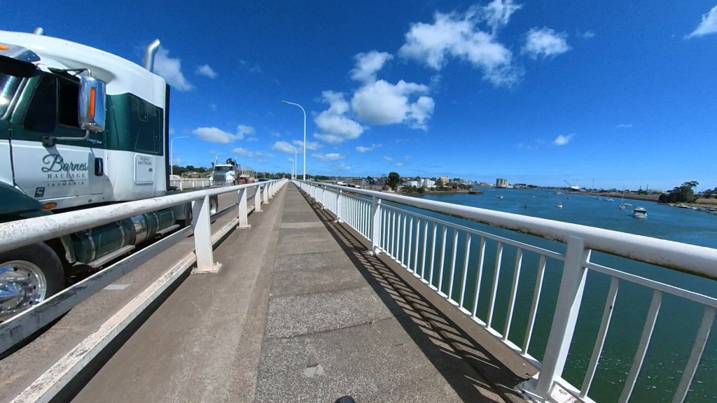
Riding the bridge is like riding between two different worlds. On the left is the busy highway while on the right you look out over the river – a very different view. Enjoyable if you can ignore the sound (and smell) of trucks dieseling past your ear.
Once on the west side the trail takes riders downstream to skirt the Devonport CBD then up to the Bluff at the mouth of the Mersey. This is a ride the trike and I have done quite a few times before. A couple of years back there was a lot of work going on to improve roads and fit in new buildings and, at that time, cycling was a little tricky. Now it is all finished and no hassles at all as long as you avoid all the other riders plus dog walker, pram pushers and everyone else using the shared path. Great to see so many people out and aboutand it’s a nice part of the ride.

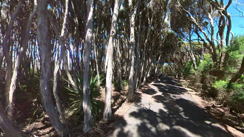
After the Bluff we wind our way through delightful stands of Tea Tree. It makes a scenic avenue but the trail is usually busy (as it was today) and some cyclists just can’t keep in their lane when blind cornering. There was only one surprise “almost meeting” today but I nearly wore him on the front of the trike – like a mascot. Luckily it was a miss so Ernie wasn’t usurped from his mascot duties.
Travelling through the beachside car parks, the trail finally pops out the end and runs a little way upstream by the side of the Don River to the new bridge built to carry the Coastal Path.

I came along to the bridge opening event last year.

Crossing the Don River you have the railway bridge to the left and the Don River mouth to your right. At the mouth the Don unloads into Bass Strait.
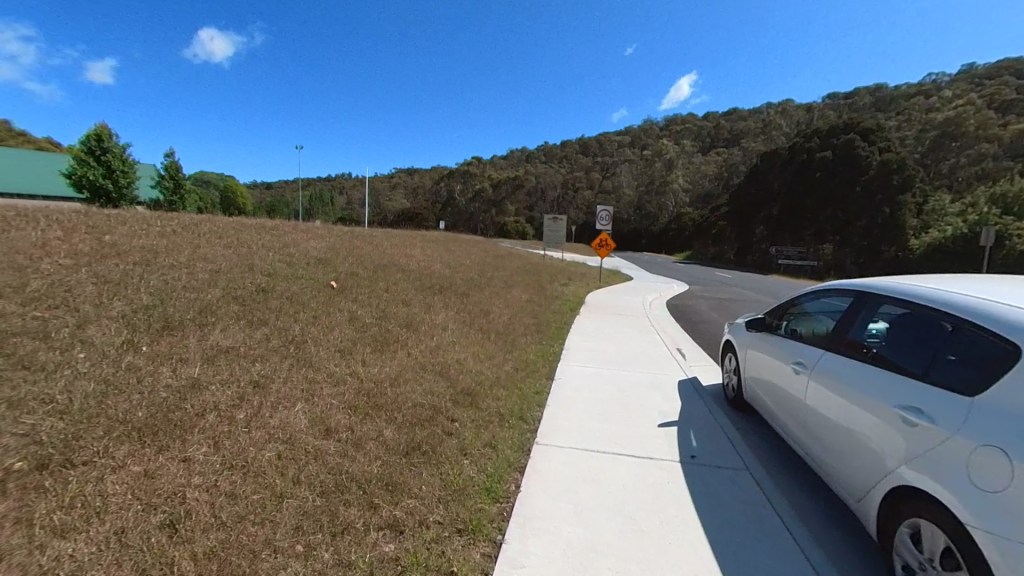
Once across the bridge the pathway decants riders onto a quiet rural road. Here you can ride along to the start of another path to take you into Don or now, after the new work, you can climb a hill, turn right and roll along to the new section of pathway. The section that is the objective of my ride today.
The route now takes us down and under the Bass Highway. Today the surface of the descent and the tunnel is covered in wet gravel – the result of heavy electrical storms a few days ago. I’m thinking that when there is a really good wet the tunnel may be impassable.
After the tunnel the trail is windy and hilly. Short sharp hills going through some obvious farmland. There is a really bouncy cattle grid at the start, lots of gates with notices on advising the path is temporarily closed due to stock movement and then a final cattle grid as bouncy as the first. How would you be hitting this section on cattle movement day? A wait at one or more gates as cattle wander down the trail then a ride through whatever the cows have left behind! Mudguards (fenders) are useful at such times.

Then there is a great downhill with views across to the distant Bass Highway and Bass Strait. It’s windy here today on this exposed section.
The trail is wide and has a good tarmac surface – very nice. The trouble with tarmac surfaces is that they tend to crack after a couple of years and end up with more tarmac poured into the cracks to hold things together. Anyway, it’s great at the moment.
What I am noticing is that, where the track is contouring along any sort of drop, there is nothing to stop a bike going over the edge. I then realised this is true for the entire trail. There are some pretty deep drop-offs where cyclists could end up bouncing off rocks into the Mersey on the Latrobe to Devonport section. Other drops would scare a cyclist but be recoverable if the rider was any good. On a trike we would simply overbalance and go down many of the edges – it will be good policy not to let the thoughts drift too much.

The track now moves gradually closer to the Bass Highway which is busy and noisy. Luckily I had left my hearing aids at home.
At one point the trail crosses a road. To prevent motor cyclists getting onto the trail there is a set of staggered access bars and they proved difficult at first for the trike. I had to get off and manoeuvre the machine around. Taking the entry as wide as possible I was able to get round the second barrier with just a bit of backing.

We now roll along through farmland and, by focussing on the inland views, it’s a nice ride. Approaching Leith it starts to climb and reminded me a bit of the Patrick Jonkers Veloway I rode into Adelaide a few years back. The Veloway follows close by the highway. The highway has gentle gradients to look after the vehicles while the Veloway spends all its time climbing and descending presumably because there was no money to flatten it out to match the highway. It felt the same here as I rode the final section to the highway underpass to get into Leith.
The section through Leith has been improved since my last visit and now boasts a wide concrete pathway much of the way to the new bridge over the Forth River.
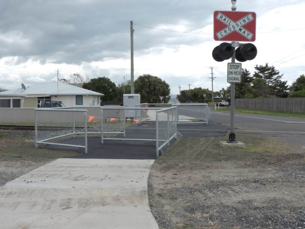
I did wonder about this though. A crossing control no doubt being installed because train drivers are often worried by people racing the train to the crossings – so this to control walkers and cyclists I suppose. It’s simple to bypass though as can be seen by the tracks to the right – which I used.
The new section through to the new bridge(a repurposed railway bridge) is good, as is the short section on the Turners Beach side which leads onto residential roads. The problem then is there are no signs explaining where to go next. Luckily I know!
I had a pedal around Turners Beach checking out the site of the old La Mar cafe (which remains a building site) and along the banks of the Forth River, simply because it’s a nice ride. Then I rode down to the start of the Turners Beach to Ulverstone part of the trail – another section I have ridden many times.
Today many Native Hens, commonly known as Road Runners or Turbo Chooks, were running about crossing the trail, running alongside and forming family gatherings in the hinterland. The conditions must be just right – they seem to like the lifestyle.
About this stage the 360 camera started turning itself off. Why? Don’t know yet.

From there it was quickly into Ulverstone through the busy park and along to the Beach Hut Cafe where I had lunch while waiting for Colin.
Colin had been dealing with family matters at the local Hospital and he turned up looking a bit hassled. He needed lunch and I needed another coffee as the one at the Cafe had been not so good. So we found another place, Colin ordered his lunch while I had a decent coffee.

The wind was blasting here (and a bit cool) and so we found a spot where the picnic tables have been protected by glass or plastic panels to ward off the winds from the river / Bass Strait. They work OK and lunch was on.
We caught up on news, ate, drank and got ready for the return trip.
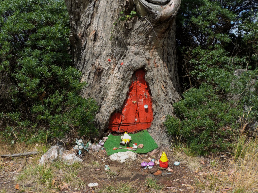
but on the way I did find this little cameo of a treehouse with gnomes catching the sun.


That’s about it. Colin was picked up in Latrobe and I loaded trike and riding stuff into the car/trailer and drove back to Longford. The traffic wasn’t too bad today and all the way home I was able to listen to Day 2 of the Australia v Pakistan Test Match from Perth.
It’s that time of the year to wish everyone a Merry Christmas. Have a good one and, like me, get to thinking about New Years Resolutions that will get all of us out cycling more in 2024.
’till next time ……………….
Whoops – nearly forgot :

A really nice ride, and a great place for a cyclist to retire to./
LikeLike
Very enjoyable ride indeed
LikeLike
Really enjoyed the video, Tont. Curious about camera management when on the move. Hand-held? Trike-mounted? Best wishes for Christmas to you and Sue.
LikeLike
It was a mixture for this ride. Two cameras – the older DJI Osmo and the Insta360. The Osmo is hand held on a tripod. The Insta is on an extendable pole clamped to the trike. Usually clamped to a bar st the front but when the hood is not up, clamped to the rear of the seat. The Insta is great as you can pick footage up from all around at video creation time. It also allows some level of zoom. The Insta started off OK but then decided it would shut down before I told it to. There’s plenty of room left on the card and lots of charge so I haven’t yet worked out why that happened. It certainly wasn’t too hot!!
LikeLike
Sorry Tony. Tont = shaky old fingers up here.
LikeLike
And I’ve just been “Yoni” in an e-card from my Scottish step cousin. Old fingers up there too !!
LikeLike
Nice! I really must plan a trip up North to ride some of these.
LikeLike
The trail should be ready between Ulverstone and Penguin soon. Some has been laid but there’s a tight, bendy section where the route is still being settled.
LikeLike
Looks like they’ve done a lot of work on this and looks like it would be a nice ride on a nice day. Glad those barriers were just “U”s instead of “W”s. It certainly looked the highway would be no fun to ride so it’s good there’s an alternative.
LikeLike
During our Christmas drive to Stanley I found quite a bit more of the trail has been built or is in the process. Going into Penguin and after Burnie – but only the road links the trail sections at the moment.
LikeLike